[Introduction]
[Methodology] [Greek and Roman Corinth]
[Modern Corinth] [Contributors]
[Reference] [News]
Greek City, pre-146 BC | Roman History | 146 - 44 BC | 44 BC | AD 70s | Roman Forum, AD 150 | Grid Plan
|
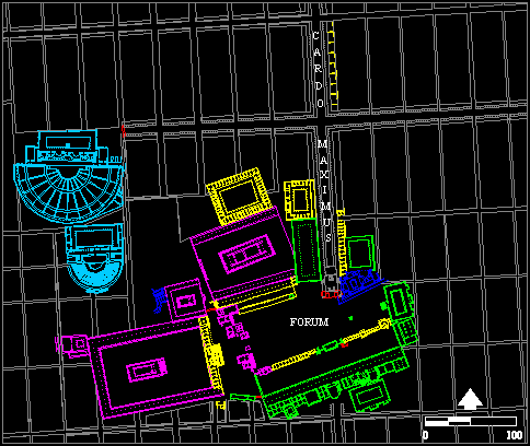
This image shows the location and organization of the major public, civic and religious buildings of the center of Roman Corinth, ca. A.D. 150. The building plan is based on the drawing by C.K. Williams, II, Hesperia 56, 1987, fig. 1, and represents the results of fieldwork, study and publication by Williams and the Corinth Excavations over many years. The building plan has been supplemented by the results of the architectural survey of the buildings and monuments of the ancient city by the Corinth Computer Project that relates to their location and orientation and the resulting Roman city grid (1 actus wide insulae). The religious buildings are colored magenta, the markets are yellow, the springs and fountains are blue and the places of assembly are cyan. Green generally represents civic and political buildings and structures. Monumental arches are colored in red. The grid of the Roman city is seen in gray and the principal north-south street of the Roman city, the cardo maximus, is seen entering the forum from the north and exiting the South Stoa to the south.
|
© David Gilman Romano and the Corinth Computer Project.
Site design and maintenance by Dan Diffendale