[Introduction]
[Methodology] [Greek and Roman Corinth]
[Modern Corinth] [Contributors]
[Reference] [News]
Greek City, pre-146 BC | Roman History | 146 - 44 BC | 44 BC | AD 70s | Roman Forum, AD 150 | Grid Plan
|
Roman Grid Plan, 44 B.C.
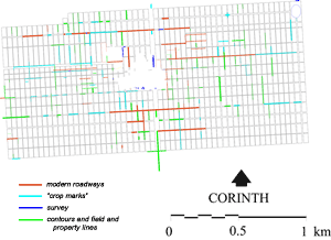
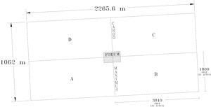
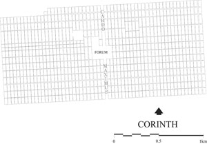
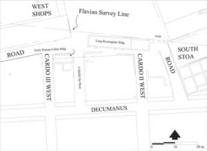
Altogether the combined evidence suggests a colonial plan, the overall area of which was based on four equal quadrants or centuries, each 32 X 15 actus or 240 iugera. There exist a total of 29 cardines and 29 one actus wide insulae, in each of the four centuries, as the colonial city planner designed it, although there may have been some modifications between design and use. The westernmost insula of the eastern two centuries included the cardo maximus, the principal north-south artery, which had reserved a width of 50 feet (including the sidewalk). The average width of the remaining cardines appears to be ca. 12 feet. There were likely six decumani in both the southern and northern half of the colony for a total of 12, resulting in an average width of 20 feet each. As is common in Roman colonies and cities, a political, social and economic 'center of town' was reserved from the earliest planning of the colony, and this seems to have been the case at Corinth. The central public area that would have included the forum as its major component appears to have been originally designed for an area of 24 square actus or 12 iugera; 6 city insulae east-west and 4 city insulae north-south. This entire area comprised the topographical center of the colony, with the location of the rostra as the central feature of both. This arrangement would have meant that equal space, 6 square actus or 3 iugera, would have been utilized from each of the four intersecting centuries for the composition of the forum (Figures 2, 3). Neither the cardo maximus nor a major decumanus of the city actually intersected at the rostra but the axes of these roadways, from the point of view of the original city planner, certainly did. There were, of course, other public areas near the center of the colony that would also have been used by the citizens, for instance the theater to the northwest, but it would likely have been a separate area from the standpoint of Roman colonial planning. The actual area of the forum was planned to be a relatively small proportion of the urban area of the colony; 12 iugera out of a total area of 812 iugera or 1.48 %. It is also clear that from the earliest Roman colonial plan, a number of Greek structures were located within the area reserved for the Roman forum, principally the Hellenistic South Stoa. Although there may have been some variation in the number of decumani of the urban area from century to century, each of the resulting four centuria strigata (29 X 14 actus), which was the land exclusive of the roadways, and additionally the land excluded by the forum, would likely have been originally planned for 200 iugera. Within each of the four large centuries of the colonial city can be reconstructed insulae based on the available evidence. The insulae are one actus wide , east-west, and from the combined information of archaeological evidence, air photographs and modern lot lines and in some cases topographical features, appear to vary in north-south length between one and four actus (120 and 480 feet). There is growing evidence for what the 44 B.C. colonial plan may have been; It is clear that it was a per strigas plan for the colony, and likely to have been a combination of 1 X 1, 1 X 2, 1 X 3 and 1 X 4 actus insulae. Because of topographical considerations, as well as considerations of earlier existing monuments, there would have been variations in colonial design that are reflected in this layout. These insulae are divided by roads, both east-west decumani and north-south cardines. Some of these one actus squares are still visible in modern lot and house lines and still can be found in several parts of the modern village of Ancient Corinth as well as in nearby Anaploga. There were, in addition to the Roman insulae and roadways, earlier Greek roadways that were likely respected by the Roman colony. The best source of information about the measurement of the insulae as one actus wide, as well as information about the specific length of the foot measure employed in the Roman planning of the colony, comes from a block that has been measured in the area of the southwest forum, between cardo II west and cardo III west (Figure 4). Between the exterior faces of the walls of the existing buildings the surveyed measurement is 35.486 meters which gives 120 feet of 0.295 + m. The fact that the sidewalks as well as the roadways would not have been included in the 120 foot wide insulae suggests that the Roman legal term iter populo non debetur, "the public thoroughfare is not indebted" was the system of land division employed in the urban Roman colony. This would have meant that the roads were not included within the measured 120 foot wide insulae, but were constructed outside of the insula blocks. As a result of this field survey we know the north/south orientation of the east curb of the cardo maximus (and the colony) to be N03d 3' 46"W and the orientation of the south curb of the major decumanus, south of the South Stoa, to be N86d 56' 09"E, a difference of only 5 seconds of one minute of one degree from being an exact ninety degree difference. An obvious planning consideration of the Roman architects and engineers was that the Roman colony of Corinth in its limits, fit well within the Greek city walls of the former Greek city to the east, south and west. Only on the north is there a relatively small portion of the northwest century of the urban colony that does not fall within the Greek city circuit wall. On the other hand, to the north of the northeast quadrant of the colony, and technically outside of its limits, is a wide and fertile plateau that lies well within the Greek city circuit wall and which logically would have been utilized for agricultural purposes by the colonists. It appears from the evidence of the field lines and the 'shadow lines' that on this portion of the land an earlier scheme of land division may have been retained. The east-west northern limit of the urban colony comes very close to the line of the Late Roman wall, found to the west of the Gymnasium and southwest of the Asklepieion. The east-west southern limit of the colony is found close to the location of the Hadji Mustafa fountain, a spring likely to have been used in both Greek and Roman times. The location of the fountain is included within the Roman colonial plan. There is a rapid rise in the lower slope of Acrocorinth immediately to the south of the fountain house and the scarp, or a portion of it, may well have been the southern line of the colony. The eastern north-south limit of the colony falls just to the east of the later built amphitheater. The western north-south limit of the colony is close to the western edge of Anaploga. It is clear from the nature of the plan of the Roman colony that from the beginning a number of the Greek city gates were used by the Romans. The evidence for this use is the extension of many of the major thoroughfares of the Roman colony, east-west as well as north-south, known from the archaeological evidence of the roadways and from air photographs, beyond the limit of the colony to or toward the Greek gates (Figure 4). There are also a number of irregularities of the Roman plan that may have to do with the previously existing Greek roadways and Greek gates. Although the overall system of the Roman colony was surveyed and set out according to a "new" orientation, it appears that the Romans did employ some aspects of the previously existing Greek orientations in their planning strategy. The axis of the open area of the forum proper, north of the South Stoa, was laid out at an orientation that was not in keeping with the grid of the Roman colony but rather in keeping with the orientation of certain Greek structures and roadways in the center of the Greek city as well as certain "Greek" land division lines to the north of the Roman colony. Later in the history of the Roman colony a number of important Roman buildings were built according to the same axis, the Julian Basilica, Temple E and the Temple E precinct as well as some of the small temples at the west end of the forum. What have we learned about the actual work of the Roman agrimensor, his assistants, the finitores, and their method of laying out the colony? The Roman surveyor with his principal surveying instrument, the groma, would in the earliest stage of surveying, have set up his instrument high on the southern slope of Acrocorinth, likely above what would become the southern limit of the urban colony. The groma, which was a vertical staff with a cross mounted on a bracket, included two horizontal arms, each with two paired plumb lines and plummets. Sighting was accomplished by lining up one plumb line with its opposite number. Although a relatively simple process, the equipment was extremely accurate in the surveying of straight lines and right angles, meaning squares and rectangles. The groma would have been utilized in conjunction with one, or likely more, metae (sighting rods). From the high vantage point on the north slope of Acrocorinth to the south of what would become the forum, the surveyor could have sighted virtually the entire length of the principle north-south axis of the colony, the cardo maximus, both that within the urban area of the colony as well as the area to the north, between the Greek Long Walls, as far as 5000 m. away toward the Corinthian Gulf. From the location on the north slope of Acrocorinth it is also likely that he could have sighted the rostra, the topographical center of the urban colony and the center of the forum. After the principal north-south line of the colony had been determined, the groma would have been moved along the Cardo Maximus to measured locations where the decumani would have been sighted, surveyed and laid out. Crosschecks would have been made during this process. This survey procedure, as the principal means of measurement and division of property, would have continued for the entire length of the cardo maximus and then extended to the breadth of the centuriated area, although the details of land division would have differed to some degree in the land reserved for agricultural use (discussion below). Boundary stones, termini, would have been set up around the fines of the territorium. Following the survey it would have been likely that the forma, the plan of the urban colony including the adjoining land, the territorium, would have been set up in the forum. |
© David Gilman Romano and the Corinth Computer Project.
Site design and maintenance by Dan Diffendale


