|
History of Construction and
Use:
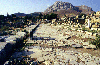
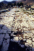
The length of the cardo maximus,
as the principal north-south roadway of the Caesarean colony
of 44 B.C. has been excavated to the north of the propylaea
for approximately 107 m. This roadway has been named the Lechaion
Road based on the description of Pausanias (2.3.2-3) of the
'direct road to Lechaeum.'
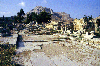
From the Augustan period there
was an important monumental arch at the place where the forum
meets the roadway. A series of steps leads down from the monumental
arch to the north to the level of the roadway itself. Although
unpaved in the Augustan period, and open to wheeled traffic,
the roadway was paved with hard limestone slabs in the time
of the emperor Vespasian and was limited to pedestrians. At
that time the thoroughfare included the road itself as well
as both sidewalks and colonnades of shops to east and west.
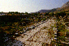
Other elements of the cardo
maximus have been discovered to the south of the forum where
there are portions of the paved roadway, both within the Hellenistic
South Stoa and immediately to its south. The Lechaion Road originally
extended 3000 m north from the area of the forum of the city
to the Gulf of Corinth. In the planning of the Caesarean colony
of 44 B.C., the cardo maximus formed the central artery
through the colonial plan. It was also one of the principal
north-south lines of the Roman agrimensores' plan for
the urban and rural elements of the colony.
Pictures from the Lechaion
Road:
Testimonia:
Bibliography:
- H.N. Fowler and R. Stillwell,
Corinth I, Introduction, Architecture, Topography.
Cambridge, Mass. 1932, 135-158.
|
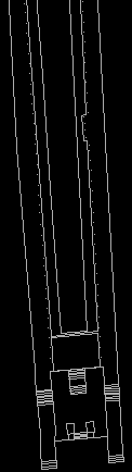
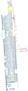
Figure 1: Restored
plan of the Lechaion Road in Corinth, A.D. 150
Click on
the figures to enlarge.
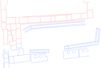
Figure
3:
Detail of the Roman latrine east of the Lechaion Road
|
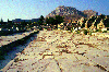
Figure
2: Actual state of the Lechaion Road
|
;)
;)
;)
;)
;)
;)
;)