|
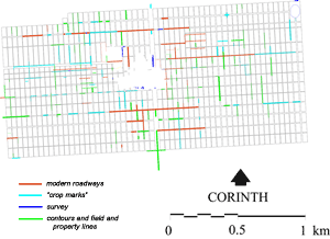
The foundation of Colonia Laus Iulia Corinthiensis by Julius Caesar in 44 B.C. is attested in various ancient authors as well as by numismatic and epigraphical material. Archaeological evidence for the organization and structure of the urban elements of the colony has been recovered from many sources, including the Roman roads of the city. Excavated roadways having the orientation and the location of the colonial period grid now number 22, 13 running north-south and 9 east-west (Fig. 3). Some have been known for many years, and several are paved. The paving may date to the years following the earthquake that damaged Corinth in the A.D. 70s.
Where the curbstones of the roadways exist, they have been surveyed by means of an electronic total station and accurately plotted within the framework of the Greek Army Geodetic Survey. To this information has been added the evidence of the 1:2000 topographical maps, which include modern village roads, ledges, paths, property lines, and contours, and of rectified low-level air photographs. This has been further supplemented by the information from Corinth Excavations notebook drawings and from topographical and architectural reports.
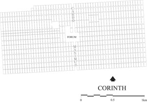
The evidence for the organization of roads within the urban plan of Colonia Laus Iulia Corinthiensis is synthesized in Figure 4. This illustrates all of the combined evidence for what I call the "drawing board" plan of the colony, the plan that the colonists may have brought with them from Rome. I use the term "drawing board" for a number of reasons. It appears from the archaeological evidence that although the urban colony was originally designed to be of a certain size and shape, and to have contained a specific number of cardines and decumani, the original, or "drawing board," plan may not have been entirely carried out, as is discussed below.
 |
 |
| Figure 3. Evidence for roadways in the Caesarian colony of 44 B.C. from all available sources (click to enlarge). |
Figure 4. "Drawing Board" plan of the urban colony of 44 B.C. (click to enlarge). |
The Planning and Orientation of the Urban Colony of Julius Caesar
The principal north-south orientation of the colony of 44 B.C. is approximately 3° west of north. The evidence suggests that the "drawing board" plan called for an overall urban design which was based on 4 equal quadrants (centuriae), each 32 x 15 actus, or 240 iugera (Fig. 5). The per strigas plan placed a total of 29 cardines and 29 insulae, each 1 actus wide, in each of the four centuriae, which would put 200 iugera of land in each, excluding the roads and the Forum. The evidence suggests that the predominant insula size of this original plan was 1 x 2 actus.
The Lechaion Road was the principal cardo (cardo maximus) of the urban colony; there is abundant evidence from the excavations in the city as well as from low-level photographs of the region near the Lechaion harbor some 3000 m to the north. In the 1st century A.D., the Lechaion Road, including its sidewalks, was 50 feet wide. The average width of each of the remaining cardines of the city grid was ca. 12 feet. In the urban center, the Lechaion Road (cardo I east) was technically a part of the eastern two centuriae of the city. There probably were 6 decumani in both the south and north half of the colony, for a total of 12, each having an average width of 20 feet.
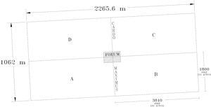
Figure 5. Schematic drawing of the four quadrants of the urban colony,
each of which is 32 x 15 actus, with centrally located forum and cardo maximus. (click to enlarge)
The original urban plan extended from the amphitheater on the northeast to the area of modern Anaploga on the southwest. The overall dimensions of the city were 2265.6 m east-west (7680 Roman feet) by 1062 m north-south (3600 Roman feet). The total area of the city would have been 2.4 square kilometers, or 240 hectares, with its entire area within the walls of the Greek city. Only at the northwest in the area of Cheliotomylos did a small section of the rectilinear "drawing board" plan fall outside the Greek circuit wall; this would not have been developed as part of the actual city.
The specific evidence that contributes to the definition of the limites of the northeast corner of the city includes the orientation and location of the amphitheater, apparently an element of the original plan. This structure has as its southern entrance one of the cardines of the original colonial plan, cardo XXVIII east. Several additional cardines in the vicinity of the amphitheater are clear from the low-level air photographs. At the southwest, in the area of Anaploga, some of the modern village streets still reflect the actus measurements. Other cardines of the "drawing board" plan are evident in the landscape from the low level air photographs (Fig. 3). Topographical irregularities as well as specific necessities of design will have caused some modifications in the original plan.
During ten summer seasons of fieldwork it was possible to survey diagnostic elements of virtually every surviving above-ground structure of the Roman city; this work has greatly added to our understanding of the planning and organization of the colony. It has thus been possible to produce a map which includes not only the "drawing board" design, locating the planned insulae and streets, but also excavation evidence drawn from actual-state plans and, in some cases, from restored plans of many of the principal buildings (Fig. 6, Fig. 7).
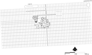 | 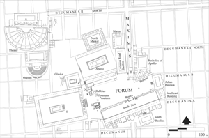 |
Figure 6. Restored Roman city plan, ca. A.D. 150, illustrating existing buildings and structures within "drawing board" plan
(click to enlarge). | Figure 7. Restored Roman city center, ca. A.D. 150
(click to enlarge) |
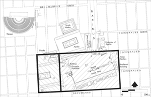 | 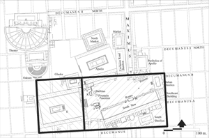 |
| Figure 8. Roman Forum planning, illustrating original 6 x 4 actus area with additional 2 x 4 actus area to west, corresponding with the early phase of Temple E (early 1st century B.C.) (click to enlarge) | Figure 9. Roman Forum planning, illustrating original 6 x 4 actus area with additional 3 x 4 actus area to the west, corresponding with the later phase of Temple E (A.D. 70s). (click to enlarge) |
The Planning and Organization of the Forum
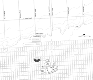
It is virtually certain that the forum, as the political, social, and economic center of the urban town, was planned for and reserved in the earliest design of the colony (Fig. 8, Fig. 9). During the Archaic, Classical, and Hellenistic periods, the upper Lechaion Road valley, which underlay the Roman forum, was punctuated with hero shrines and was criss-crossed by roadways. From the 6th century B.C. to 146 B.C. a racecourse filled some of the space of the valley (Fig. 2).
The central public area of the Caesarian "drawing board" plan was originally designed as the topographical center of the urban colony, having an area of 24 square actus or 12 iugera, with 6 city insulae east-west and 4 city insulae north-south. The area of the forum was 3% of the area of the city. The rostra is located near the center of the reserved central public area and, as such, is the central feature of both the Forum and the city.
Many of the principal Greek and Roman buildings and structures found in the area of the forum are laid out in an orientation different from that of the Roman colony of 44 B.C. (which is approximately 3° west of north). There appear to be several different systems of orientation among the buildings and structures included within the 24 square actus reserved for the Roman Forum. In the Greek period (Fig. 2), the orientation of the Archaic Temple of Apollo (ca. 540 B.C.) probably determined the orientation of the South Stoa, which was constructed ca. 330. The north-south orientation of the North Building is approximately at a right angle to the east-west axis of the Hellenistic (ca. 270 B.C.) racecourse of the upper Lechaion Road valley.
A significant similarity in orientation can be seen among a number of major Roman buildings constructed in and around the Forum between the Augustan and Claudian periods (i.e., between 27 B.C. and A.D. 54). Of particular significance are Temple E in its early phase, the West Shops, the Julian Basilica at the east end of the Forum, and the north-south peribolos wall of Temple C. Other buildings that reflect an orientation similar to these are the series of small Roman temples and monuments along the west end of the Roman Forum: Temples D, K, G and F, the Babbius Monument, and the Fountain of Poseidon (Fig. 7). The earliest Roman construction discovered on the site is a retaining wall for the west terrace; this underlies the front of Temples F and G, and runs along the east face of the Babbius Monument. The retaining wall establishes the western limit of the open area of the Forum and is of the same north-south orientation as the temples and monuments that it supports.
It should be noted that Temple E and the precinct that surrounds it would technically have been outside of the Forum as originally planned. This complex originally occupied a western appendage of 2 x 4 actus, or 8 square actus, in the earliest phase, possibly from the late 1st century B.C. (Fig. 8), and 3 x 4 actus, or 12 square actus, in the later phase in the A.D. 70s (Fig. 9). In either case this area would have been added to the original 24 square actus of the Forum. It is clear that this area was an addition, for a number of modifications in the city grid were necessitated once the temple was sited, including the closing of cardo III west and the insertion of a new north-south street, cardo IIa west, 13.75 m to the east of cardo III west.
The reasons for the addition of this road and the closing of cardo III west appear to be as follows. An examination of the colonial plan of 44 B.C., which was based on 1-actus insulae units, indicates that the original design included both cardo II west and cardo III west. Cardo IIa west was added at the time the Early Roman Cellar Building was constructed in the southwest corner of the Forum (in the last decades of the 1st century B.C.) (Fig. 10). An east-west Roman roadway to north of the Early Roman Cellar Building ran against the southern edge of the temenos of Temple E; the structure was thus surrounded on three sides by roads, and sidewalks were built against the north and east faces of the building in its first phase. Cardo IIa west had to be added because of the construction of the south colonnade of the temenos of Temple E, which restricted the direct access of cardo III west to the southwest corner of the Forum. The old roadway was thus put out of use because the new roadway provided a more direct and less obstructed circulation pattern here. An additional roadway was added parallel to and south of the south colonnade. Again, the modifications may have been carried out in the last decades of the 1st century B.C.
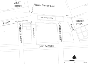 |  |
| Figure 10. Detail of the area of Forum Southwest, cardo II west to cardo III west, and the decumanus, illustrating the points at which the surveyed measurement was taken. The "Long Rectangular Building" is identified with the likely location of the Flavian survey line. (click to enlarge) | Figure 11. Roman Corinth, ca. A.D. 50, and a portion of the land divided between the long walls illustrating the north-south roadways (click to enlarge) |
The Roman Foot Measure
We have been able to measure the width of an insula between cardo II and cardo III west in this southwest area of the Forum. Between the exterior west face of the Roman Cellar Building and the exterior east face of the building immediately west of cardo II west, the surveyed distance is 35.486 m, or 120 feet of 0.295+ m (Fig. 10) . This measurement is generated from the overall plan of the city, and it is this insula interval that has been found to be constant throughout the entire urban settlement of 44 B.C. and with the area modified during the late 1st century B.C.
Territorium of the Colony of 44 B.C.
The principal orientation of the urban and the rural land of the colony in 44 B.C. is 3° 3' 46"; this measurement is based on the orientation of the excavated east curb of the cardo maximus (see above). Pausanias (2.3.2) states that the Lechaion road, as cardo maximus of the colony, extended from the Forum straight to the Gulf of Corinth and the Lechaion harbor. Our own interpretation of the low-level air photographs of the plain to the north of the city proper, based upon traces of "crop marks"—or underground features that determine growth (vegetation) patterns on the surface and so probably indicate the ancient roadway—leads to the same conclusion. Within the urban settlement the Lechaion Road has been excavated for a length of ca. 85 m immediately north of the Forum. Elements of the same roadway have been excavated south of the Forum starting in the South Stoa where it passes through the building and continues to the south. Another section of the paved cardo maximus has been discovered some 195 m further to the south.
It is clear from the low-level air photographs that what I have interpreted as the extension of the Lechaion Road in the plain to the north of the city does not coincide with the nearby road of the agricultural land division into 16 actus– and 8 actus–wide strips. Archaeological evidence does exist for a roadway parallel to the Lechaion road, as was reported by Parsons in 1936. The archaeologically attested road is ca. 35 m east of the proposed northern extension of the cardo maximus in the plain. Evidence thus suggests that there were two closely spaced parallel north-south Roman roads in this area (Fig. 11). The attested roadway was probably first laid out in the survey associated with the lex agraria in 111 B.C., and the extension of the Lechaion Road, as cardo maximus, was a later addition associated with the city after 44 B.C.
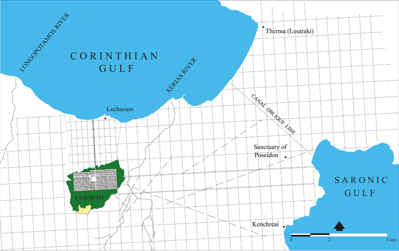
Figure 12. Caesarian colony, 44 B.C., north and east of Corinth including the rural land division composed of 16 x 24 actus units (8 x 12 actus units between the long walls) and including oblique lines as canal and suggested roadways.
The northern extension of the cardo maximus toward the Lechaion harbor invites one to consider the coastal plain beyond the limits of the city. A detailed study of the 1:2000 topographical maps, as well as the low-level air photographs, identifies at least three systems of land organization here. One system is likely to be Greek and two Roman. The most conspicuous division is the one with 16 actus–wide units at an orientation of 3° west of north (Fig. 1). This system extends from the northern limit of the Roman city virtually to the coastline and is 72 actus long. There are four north-south 16 x 72 actus strips, each subdivided into 16 x 24 actus units, with some evidence of further division into 8 x 12 actus units. The same system of land division (Fig. 12) continues westward in the plain north of the city as far as the Longopotamos river and eastward along the coast as far as modern Loutraki. Elements of the same system have been documented to the south of Corinth as far as the town of Cheliomodion (perhaps the area of ancient Tenea) and to the southwest as far as Kleonai.
(Back to the Interim Period, 146-44 BC) | (Forward to Colonia Iulia Flavia Augusta Corinthiensis, AD 70s...)
|
;)
;)
;)
;)
;)
;)
;)
;)
;)
;)
;)
;)
;)
;)
;)
;)