|
Decumani
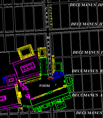
Figure 1
Location of the Decumani in Corinth, A.D. 150
This page discusses the east-west roads
(decumani) seen in the city plan. Click the links below for an
individual description of each road.
E-W Roads:
Decumanus A
This information will be added later.
Decumanus B
This information will be added later.
Decumanus I
This information will be added later.
Decumanus II North
|
This roadway is one of the principal
east-west thouroughfares within the heart of the Roman City. Located
approximately 245 meters to the north of the rostra in the forum.
The roadway connects the eastern aspect of the theater with the
unexcavated monuments of the eastern city. Decumanus II north
intersects the cardo maximus at a point that must have been one
of the principle intersections of the Roman city. The length of
the road is likely to have been approximately 400 meters.
At the point where the roadway
meets the area of the theater there exists a monumental
gateway. The roadway is paved with hard limestone by the second
half of the 1st century A.D. and is characterized by a sidewalk
and a colonnade on both sides of the street. The exact width of
the street is not known but it is wider than 4.75 meters. The
roadway was restricted to pedestrian traffic and together with
the Lechaion Road cardo maximus it created an urban armature
for pedestrian use.
|
Bibliography:
- Williams, C.K. II, O. H. Zervos,
"Corinth, 1981: East of the Theater: The Paved East-West Road,"
Hesperia 51 (1982) 128-132.
- MacDonald, W.L, The Architecture
of the Roman Empire: An Urban Appraisal," Vol II (1986).
|
Decumanus III North
|
  
  
|
This east-west roadway was one of
the primary arteries of the Roman city. Extending some 2200 m.
from east to west, the roadway linked the Greek circuit wall at
its northwest corner with the north central part of the Roman
city. The roadway also extended to the east in the city to the
area of the amphitheater. This roadway was open to wheeled traffic
for its entire length and was likely one of the principal roadways
used for commercial purposes during the Roman period.
This roadway was an important component
of the Roman insular city plan that was imposed on the former
Greek city in the first century B.C. The Lechaion Road as the
cardo maximus was the principal north-south artery of the
Roman city plan.
|
Decumanus
| One of
the principal east-west thoroughfares of the Roman city of Corinth.
This road passed immediately to the south of the forum and extended
over 2 kilometers. The road was, by the last quarter of the first
century A.D., paved with limestone blocks and measured between 3.59-3.77
meters wide, with sidewalks on both north and south sides of the
street. Wheel ruts in the limestone paving blocks indicate that
this roadway was used for wheeled traffic and was likely to be one
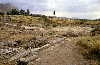
of the major commerical arteries of the city. |
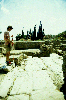
 Actual State
of a section of the decumanus
Actual State
of a section of the decumanus
(Click figures to enlarge) |
Bibliography:
- David Gilman Romano, Athletics and
Mathematics in Archaic Corinth: The Origins of the Greek Stadion,
American Philosophical Society, Philadelphia, 1993.
- David Gilman Romano, "Planning the
Forum in Roman Corinth," American Journal of Archaeology, Abstract,
1998.
- David
Gilman Romano and Nicholas L. Stapp, "Piecing Together the City and
Territory Roman Corinth," Archaeological Computing Newsletter,
Number 52, Winter 1998, pp. 1-7.
|
;)
;)
;)
;)
;)
;)
;)
;)
;)
;)
;)