[Introduction]
[Methodology] [Greek and Roman Corinth]
[Modern Corinth] [Contributors]
[Reference] [News]
Intro | Modern Surveying | Aerial Imagery | Satellite Imagery | Topographic Maps | 3D Modeling | GIS Analysis
| The methodology in this project
may be conveniently divided into field and laboratory segments. The laboratory
work is carried out to a limited extent in Corinth in summer and in the
Mediterranean Section of the University Museum in Philadelphia during
the remainder of the year.
Field Methodology
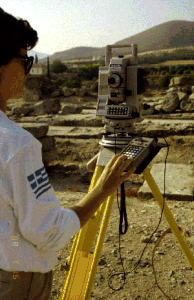
The field equipment includes a SOKKIA (formerly Lietz) Set-3 Total Station (which has two major components: the electronic theodolite and the electronic distance meter [EDM]), a SOKKIA SDR-2 hand-held portable computer, prism reflectors, and walkie-talkies. In the field house is a Zeos 486, 66mhz machine with 32 MB RAM. The battery-operated portable computer, SDR-22, with 64Kb of memory is capable of storing over 2200 field observations and has resident in it a dozen survey and trigonometric functions. Many typical operations, e.g., inverse, resection, traverse, and computation of plane coordinates, can be executed by the hand-held computer and stored in its memory. At the end of a day's surveying in the field, the memory contents of the SDR-22 can be transferred to the microcomputer in the field house. It was found advisable to make this transfer after approximately 300 to 400 measurements had been made (usually meaning at the end of the survey day), since each sighting often requires multiple observations by the instrument, thereby using up even more memory. The hand-held computer runs on four alkaline AA batteries and can send survey data directly to a portable printer so that data can be reviewed on paper while in the field. The stored field data can be transferred to the microcomputer by a survey link program, which then facilitates the editing of the data, its organization, and eventual sorting and plotting.
Field Methodology: Field-Data Collection Methods Each member of the survey team, which
ideally numbers four, is given an individual assignment. The instrument
person, as chief surveyor, is in charge of all aspects of the operation
of the EDM and the technical work of the survey in general. An assistant
at the instrument aids the chief surveyor by keeping a written operation
log which includes details of all of the work undertaken. As with any standard optical equipment,
the most important aspect of the survey routing with electronic equipment
is the setup procedure. This must be done precisely in order that the
accuracy of the day's data can be ensured without tht need of further
processing. Therefore, the setup coordinates are checked several times
before the day's work is begun. If the sighted coordinates of a setup
point differ by more than 7mm from the known coordinates, the setup
is redone or different secondary points are used. Each day's activity
is begun by leveling the instrument and testing the battery. A review of the day's survey data can be made during field operations by looking at the data review screen of the portable computer. The day's data can also be printed out directly from the SDR-22 using the portable field printer. In this way any difficulties or errors with the field operations can be immediately recognized and corrected without having to return to the field house. At the end of the day's work the data are transferred from the portable computer to the microcomputer in the field house, where data editing and storage are completed. Sokkia survey software enables direct transfer of survey data using AutoCAD's file exchange format (DXF).
Field Methodology: Field Records Hand-written notes, sketches, and, at times, photographs have been found to be absolutely necessary to provide details of each building, grave, monument, or road. These show where the surveyed points were located, how the points should be connected (i.e., by line or arc), and whether lines or arcs should be extended to make corners, and thus simplify the processing of finished drawings. Usually, sketches were made indicating the location of each point and each number in relation to the surveyed item, and a list was kept showing the point number and pertinent information such as the course or the type of material (wall, trench, foundation, scarp, rubble, etc.) and the location on the formation (the particular face of the block, the center of a column base, etc.). In order to make the points transfer to the drawing more directly, point description information can be coded onto the computer as the points are being taken, or later during the editing stage. Each of the computerized survey jobs as well as the points within them receive consecutive numbers so that if there is a question about a particular surveyed point, the number can be located in the computer drawing and found in the printed survey data and field notebooks. For each job, the setup coordinates, any problems encountered with them, and the associated plane transformations (discussion below) are also documented. Being able to refer to such information makes it easier to reconstruct the buildings and to overlay state-plans accurately. Field Methodology: Plane Transformations Occasionally there is a need to adjust, within the overall grid of the city, the location of an otherwise accurately surveyed monument or structure. This procedure involves the use of trigonometric functions to adjust field data so that they will conform to the geodetic coordinates. A plane transformation is actually a simple process that can be explained by comparing survey jobs in a landscape to a piece of paper fastened onto a bulletin board with thumbtacks, the tacks being analogous to bench marks in the survey. If the survey was accurate to begin with, the scale will remain the same when the points are moved to their new locations. This is similar to moving the piece of paper by placing the tacks in a new position on the board without removing them from the paper. The plane transformation function can be carried out by hand, but in this case it was accomplished by using a function in MAP, survey software produced by the Sokkia Company. In order to account for differing degrees of setup error in each job, each survey job is treated as a separate entity f or the purpose of plane transformations. If there are slight problems with the secondary coordinates, the "perceived coordinates" returned by the Total Station will reflect an adjustment made in order to create a grid based on true distances. For this reason, rather than relying solely on the given coordinates of the bench marks, the average "perceived coordinates" are calculated from multiple readings on the points. This adjustment prevents corruption of the survey data and allows plan transformations to be carried out accurately. In this project, "reliable coordinates" are those for which there is the smallest difference between the input and perceived coordinates. This difference was limited to approximately 7mm, which is just above the distance-error tolerance of the equipment. Choosing a pair of reliable coordinates on opposite sides of the Roman Forum, all other secondary coordinates were observed in the area. This process was continued until every major excavated area of the city was linked together like pieces of a puzzle. This data-integrity check, a form of triangulation, resulted in secondary coordinate changes of between 3 and 25 mm. Laboratory Methodology: Equipment The PC's in Philadelphia run on the Windows 98 platform and are all Pentium or Pentium II class machines. The PC's, six in total, range in CPU speed from 300 mhz to 100 mhz. One of the machines (166 mhz) is a laptop which has a docking station in Philadelphia, but is also used as a field machine in Corinth. All of the PC's are networked together, using the neighborhood network option in Windows 98, to allow the user access to all of the disk space on the six machines in the laboratory. The resulting available hard drive space in the lab is 20.5 gigabytes. Although this kind of storage space is not absolutely necessary, it can and has been filled up quickly when creating and manipulating large files (10-20 megabytes) in raster and vector format. Each of the PC's in the lab have between 32-192 megabytes RAM. All of the data produced in the lab (vector, raster, html format) are routinely burned on CD-ROM using an internal CD writer. Each CD allows for 675 MB of storage space per disk. Additionally, one of the machines has an internal Jazz drive (1 GB storage space per tape) and a ZIP drive (100 MB per tape). The external input devices used are an 8.5x14 inch flatbed scanner (HP Scanjet Iic), a high resolution slide scanner (Microtek ScanMaker 35t plus) and, initially, a 44x60 inch digitizing tablet (Calcomp Drawingboard III). Large maps and plans (larger than 8.5x11 inches) have been scanned commercially on an E size (43x33 inches) sheet scanner. All digitizing is now done 'on screen' and without the digitizing tablet. The output devices have been black and white laser printer, 8.5x11 inches (Tektronix Phaser 200i) or E size eight pen color plotter (Calcomp 1025 Artisan). Laboratory Methodology: Software The main objectives in the choice of software have been versatility, ease of use and, whenever possible, direct compatibility. The principal computer program utilized in this project and the vehicle with which the other computer programs work is AutoCAD R14 (Autodesk, Inc.). AutoCAD provides the facility to draw on an unlimited number of "layers," which can be compared to superimposed transparent sheets for a hand-drawn map. This aspect of the program enables parts of the map to be turned on and off for analysis and is especially helpful in manipulating different types of information on topographical maps. AutoCAD also includes three-dimensional drawing and rendering capability; reconstructions of buildings will be facilitated with this program. All maps, drawings and images are digitized and managed using AutoCAD. The field survey data is directly translated from a hand held computer to the laptop, using survey software (Sokkia Map 6.0). This translated data is in DXF format. Air photographs and topographic maps are scanned into raster format and viewed within the AutoCAD environment using Softdesk 8 Imaging (Autodesk, Inc.). This software works as a module within AutoCAD R14 and allows the user an additional menu setting for image manipulation. Additionally it allows the user to manipulate the raster image's contrast, sharpness and file format. Softdesk civil engineering and survey software has been used in the project primarily for the input of topographical map information. The "Digitize Contours" function and others from the Digital Terrain Modeling module have been useful in converting the data from paper topographical maps to 3D computer maps as well as in managing the contour intervals. Previous versions of CAD Overlay mdules GSX and GSX2 (Image Systems Technologies) allowed the user to interactively manipulate the contrast and brightness of the image with a single stroke of the keyboard. Although the current software has more image manipulation options, adjusting contrast and brightness is a minimum three-step process and very time consuming. Softdesk 8 Imaging also allows a raster image to be rubber sheeted, stretched, cropped, merged and rectified to known or desired coordinates. Additional image manipulation is done using GIS software, IDRISI (Clark University) and AutoCAD Map2 (Autodesk, Inc.). The project also uses 3D Studio (Autodesk, Inc.) to produce three-dimensional renderings of architecture and digital landscapes. Database management is carried out with MS Access 97 and MS Excel. Laboratory Methodology: Routine Procedures A large portion of the first phase of the Corinth Computer Project has been devoted to the input of graphic data to supplement the survey information collected in the field. This has included the digital conversion of a series of topographical maps produced by the Greek Geodetic Service. The maps, confirmed as reasonable accurate by resurvey, together serve as a base map for the project. The aerial photographs used to create the maps have also yielded a great deal of supplemental information in the form of "shadow lines," or "crop marks" as they are sometimes called, which can reveal the former course of roads and, in some cases, ancient property divisions as well as the location of buildings and monuments. Some field notebook drawings have been digitized or redrawn using incorporated measurements, when there are no other plans available. |
 The electronic theodolite is used for standard angle measurements and
the EDM for distance measurements. The factory specifications of the
equipment include an accuracy in angle measurements of 5 seconds of
one degree, and in distance measurements of 5mm with a maximum range
of 2800m (with a triple prism reflector). Distances are measured by
means of a modulated beam of infrared light that is emitted and reflected
back to the instrument through a prism. The infrared light is also used
in all angle measurements. The Total Station, which is powered by small
rechargeable batteries, has built into its memory a number of self-contained
functions which include the measurement of slope distance, horizontal
distance, and vertical distance as well as more specialized functions.
From three known positions in the field, the instrument can determine
its own location in three-dimensional coordinates, store this information,
and then automatically calculate the three-dimensional coordinates of
any point that can be sighted within the range of the instrument.
The electronic theodolite is used for standard angle measurements and
the EDM for distance measurements. The factory specifications of the
equipment include an accuracy in angle measurements of 5 seconds of
one degree, and in distance measurements of 5mm with a maximum range
of 2800m (with a triple prism reflector). Distances are measured by
means of a modulated beam of infrared light that is emitted and reflected
back to the instrument through a prism. The infrared light is also used
in all angle measurements. The Total Station, which is powered by small
rechargeable batteries, has built into its memory a number of self-contained
functions which include the measurement of slope distance, horizontal
distance, and vertical distance as well as more specialized functions.
From three known positions in the field, the instrument can determine
its own location in three-dimensional coordinates, store this information,
and then automatically calculate the three-dimensional coordinates of
any point that can be sighted within the range of the instrument. 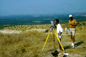 The
assistant also operates the walkie-talkie to communicate with other
members of the team. Each of the other two field surveyors, sometimes
working at a distance, has a separate assignment. One surveyor is assigned
to hold the prism pole at the proper point on the monument or structure
being surveyed. The other surveyor is responsible for accurately recording
the details of the point being surveyed. This usually takes the form
of simple drawing and notes, sometimes including measurements, although
it can also include photographs. The field surveyors utilize a walkie-talkie
to maintain constant communication with the chief surveyor. A team of
two, eliminating the assistant on both ends, is possible, although the
time needed for the process would be increased considerably and the
possibility for error increased as well.
The
assistant also operates the walkie-talkie to communicate with other
members of the team. Each of the other two field surveyors, sometimes
working at a distance, has a separate assignment. One surveyor is assigned
to hold the prism pole at the proper point on the monument or structure
being surveyed. The other surveyor is responsible for accurately recording
the details of the point being surveyed. This usually takes the form
of simple drawing and notes, sometimes including measurements, although
it can also include photographs. The field surveyors utilize a walkie-talkie
to maintain constant communication with the chief surveyor. A team of
two, eliminating the assistant on both ends, is possible, although the
time needed for the process would be increased considerably and the
possibility for error increased as well. 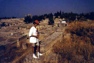 Then
the reflector is sighted at the first of our known coordinates through
the lens of the instrument. A reflector ca 7.5cm on a side mounted on
a telescoping metal pole, with an accurately measurable length, is used.
The reflectors contain prisms designed to reflect the infrared light
sent out by the Total Station back to the instrument. The instrument
sends out over 4000 pairs of infrared emissions of two different frequencies
and wavelengths, and measures the wavelength phase-shift indicated by
the light reflected back to the instrument. The instrument then calculates
an average reading and returns the distance to the sighting point. Our
maximum distance measurement for this process when there is no haze
is ca. 2200m with a single prism and ca. 2800m with three prisms. Average
conditions in Corinth, because of persistent summer haze, provide for
a maximum distance measurement of up to 400m less in both configurations.
For optimal results, the single prism is used for sightings up to one
km, and the triple prism only for those at a greater distance. The walkie-talkies
are essential not only to direct the movements of the field surveyors
but to ensure that the correct prisms are in use.
Then
the reflector is sighted at the first of our known coordinates through
the lens of the instrument. A reflector ca 7.5cm on a side mounted on
a telescoping metal pole, with an accurately measurable length, is used.
The reflectors contain prisms designed to reflect the infrared light
sent out by the Total Station back to the instrument. The instrument
sends out over 4000 pairs of infrared emissions of two different frequencies
and wavelengths, and measures the wavelength phase-shift indicated by
the light reflected back to the instrument. The instrument then calculates
an average reading and returns the distance to the sighting point. Our
maximum distance measurement for this process when there is no haze
is ca. 2200m with a single prism and ca. 2800m with three prisms. Average
conditions in Corinth, because of persistent summer haze, provide for
a maximum distance measurement of up to 400m less in both configurations.
For optimal results, the single prism is used for sightings up to one
km, and the triple prism only for those at a greater distance. The walkie-talkies
are essential not only to direct the movements of the field surveyors
but to ensure that the correct prisms are in use.  During
the survey itself it is common to take multiple sightings of various
kinds on a structure or monument. For instance, when surveying a fortification
wall it is necessary to sight the inside face of the wall, the outside
face, towers, or other elements of the structure. Each of these may
be coded as the survey is being carried out and entered into the hand-held
computer. This makes the later reconstruction of the wall on the computer
screen more straightforward. At the same time, one of the field surveyors
makes a hand drawing of the wall, noting the surveyed point number given
by the chief surveyor, along with the feature code and any other relevant
information.
During
the survey itself it is common to take multiple sightings of various
kinds on a structure or monument. For instance, when surveying a fortification
wall it is necessary to sight the inside face of the wall, the outside
face, towers, or other elements of the structure. Each of these may
be coded as the survey is being carried out and entered into the hand-held
computer. This makes the later reconstruction of the wall on the computer
screen more straightforward. At the same time, one of the field surveyors
makes a hand drawing of the wall, noting the surveyed point number given
by the chief surveyor, along with the feature code and any other relevant
information.  Field
operations take the survey team to low-lying areas in the midst of lemon
and olive orchards near sea level on one extreme, to the summit of Acrocorinth
(563m) on the other. There are three geodetic markers within the ancient
city and a fourth is set at Lechaion on the Corinthian Gulf. In order
to employ the Greek geodetic grid within the city of Ancient Corinth,
the instrument was positioned near the summit of Acrocorinth within
sight of the three geodetic pins inside the ancient city proper at Acrocorinth,
Kraneion, and Villa Roma, respectively, and a triangle was set up upon
which to base the grid. Using the geodetic pins as the fixed datum points
of the architectural and topographical survey, coordinates were assigned
to a series of secondary positions all around the ancient site. Because
sighting these pins required observations at a distance greater than
1900m, a triple reflector for these long-range sightings was necessary.
When corrections for barometric pressure, temperature, and curvature
of the earth were applied, a small error in the initial geodetic survey
could be perceived. The earth curvature and atmospheric corrections
are only significant when sightings are to be made at a distance exceeding
1km. In the survey, nearly all of the long shots (over 1km) were used
to create secondary positions.
Field
operations take the survey team to low-lying areas in the midst of lemon
and olive orchards near sea level on one extreme, to the summit of Acrocorinth
(563m) on the other. There are three geodetic markers within the ancient
city and a fourth is set at Lechaion on the Corinthian Gulf. In order
to employ the Greek geodetic grid within the city of Ancient Corinth,
the instrument was positioned near the summit of Acrocorinth within
sight of the three geodetic pins inside the ancient city proper at Acrocorinth,
Kraneion, and Villa Roma, respectively, and a triangle was set up upon
which to base the grid. Using the geodetic pins as the fixed datum points
of the architectural and topographical survey, coordinates were assigned
to a series of secondary positions all around the ancient site. Because
sighting these pins required observations at a distance greater than
1900m, a triple reflector for these long-range sightings was necessary.
When corrections for barometric pressure, temperature, and curvature
of the earth were applied, a small error in the initial geodetic survey
could be perceived. The earth curvature and atmospheric corrections
are only significant when sightings are to be made at a distance exceeding
1km. In the survey, nearly all of the long shots (over 1km) were used
to create secondary positions.© David Gilman Romano and the Corinth Computer Project.
Site design and maintenance by Dan Diffendale