GIS Analysis: Amphitheater
|
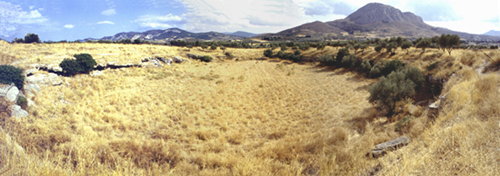
The remains
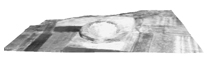
of a large amphitheater are visible approximately 1000 meters
to the northeast of the forum. A large (78.6 X 51.6 m.) elliptical
depression in the modern fields mark the remains of the ancient
facility (figure 1). The floor of the structure, arena,
and the stone seats were cut out of the bedrock and it is likely
that the original superstructure was constructed of wood. The
location of the amphitheater, in the northeast corner of the
"drawing board plan" of the Caesarean colony of 44 B.C., would
be have been in keeping with the design of Roman cities, where
amphitheaters were commonly situated immediately inside or outside
the limits of the city. A roadway, cardo XXVII east,
approaches the amphitheater from the south and served as the
principal access to the structure (figure 2). The point at which
the roadway met the amphitheater was likely to have been the
Porta Triumphalis that would have served as the entrance
to the arena for the gladiators and other performers. At the
north end of the amphitheater is a rock cut entrance that likely
would have been the Porta Libitinensis, the exit for
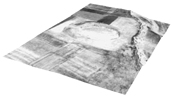
gladiators and animals. One of the only plans produced of the
amphitheater in Corinth comes from Abel Blouet, a French scholar,
who published the plan to the right in the 1830's. The plan
clearly illustrates the elliptical shape and the seating plan
of the amphitheater (figure 3).
The amphitheater was the place
where gladiatorial games, munera gladiatoria, were held.
Gladiators were usually prisoners of war or condemned criminals
and were known to be of four types: the murmillo who
carried a short sword, a rectangular shield and a helmet with
a fish crest; the Samnite who had a short sword, oblong
shield, greaves and visored helmet; the retiarius who
fought with a trident and a net and the Thraex who carried
a round shield and a curved sword. Other events that likely
occurred in the amphitheater included wild animal hunts, venationes.
It is interesting to note that
during the 2nd and 3rd centuries A.D., both the odeum and the
theater near the forum of Roman Corinth were readied for gladiatorial
contests. In both cases, the orchestras of the facilities were
converted for use. In the theater, wall paintings have been
discovered that depict gladiatorial contests and wild beast
hunts. Figures 4 and 5 are frescos taken from the theater in
Corinth. They depict scenes of gladiators fighting the types
of wild beasts that were imported into Corinth for the gladiatorial
games. Figure 4 depicts the gladiator highlighted in blue and
a lion highlighted in yellow. Figure 5 depicts two gladiators
highlighted in blue fighting a bull, highlighted in yellow.

These photographs illustrate the
amphitheater in the early twentieth century. Figure 6 shows
the northern end of the amphitheater including the subterranean
passage. Figure 7 shows the amphitheater floor and aspects of
the seats in the eastern section. Figure 8 shows the arena floor,
looking southeast.

The illustrations
below are 3D models of the amphitheater region that where made
by digitizing 1:2000 topographic maps. After digitization in
AutoCAD, the contour lines were assigned their appropriate Z
value. The 3D contour lines were then imported into ArcView
and a either a wire-frame model or a Triangulated Irregular
Network (TIN) was rendered. The final stage before analysis
was to drape ground level or aerial photograph over this 3D
model for further ground cover relief or enhanced visualization.
Figure 9 illustrates
the 3D contour lines combined with a TIN skin. Figure 10 illustrates
a 3D model with various shades of color denoting elevation change.
Figure 11 illustrates the "drawing board plan" of the Caesarean
colony of 44 B.C. draped on top of the 3D model.
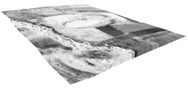
The figures below (figure 12,
figure 13, and figure 14) demonstrate how this type of computerized
data can be used for interpretative purposes. These figures
show a low level aerial photograph draped on top of the initial
3D model. Remote sensing, slope analysis and historic view sheds
are examples of useful research that can be conducted with this
type of 3D data.
|
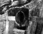
Figure 1
Click on the
images to enlarge.
Figure 2
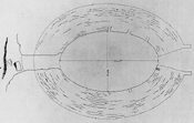
Figure 3
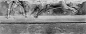
Figure 4
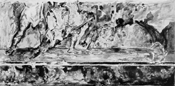
Figure 5
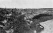
Figure 6
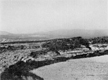
Figure 7
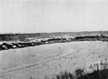
Figure 8
|
 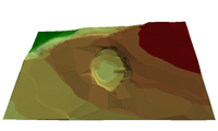
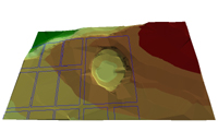
Figures 9, 10, 11
(above); Figures 12, 13, 14 (below)
Testimonia: Dio
Chrysostom, 31.121 (translation adapted from the Loeb Classical Library)
For instance, in regard
to the gladiatorial shows the Athenians have so actively emulated
the Corinthians or really have surpassed them and all others in
their mad infatuation, that whereas the Corinthians watch these
combats outside the city in a gully, a place that can accommodate
a crowd, but otherwise is dirty and such that no one would even
bury a freeborn citizen there...
Media:
 Listen
to a Real Audio broadcast from Philadelphia's National Public
Radio Station WHYY.
The show "Radio Times" features a discussion of Roman
gladiators. This radio broadcast features Professor Brent Shaw, Department
of Classical Studies, University of Pennsylvania. This show was aired
on May 6, 2000. Fast forward to the 1.05 hour mark to hear the discussion
on gladiators. Click on the Real logo to download and install the
free plug-in. Listen
to a Real Audio broadcast from Philadelphia's National Public
Radio Station WHYY.
The show "Radio Times" features a discussion of Roman
gladiators. This radio broadcast features Professor Brent Shaw, Department
of Classical Studies, University of Pennsylvania. This show was aired
on May 6, 2000. Fast forward to the 1.05 hour mark to hear the discussion
on gladiators. Click on the Real logo to download and install the
free plug-in.
Bibliography:
H.N. Fowler and R. Stillwell,
Corinth I, Introduction, Topography, Architecture, American
School of Classical Studies at Athens, Cambridge, Mass. 1941, pp.
89-91; figs. 54-56.
K. Welch, "Negotiating
Roman Spectacle Architecture in the Greek World: Athens and Corinth,"
in The Art of Ancient Spectacle, B. Bergmann and C. Kondoleon,
eds, Yale University Press, 2000, pp. 125-145.
For Further Reading:
T. Wiedemann, Emperors
and Gladiators, Routledge, London, 1995.
Figure Credits:
- Hellenic Air Force, 1963, Courtesy
Corinth Excavations, American School of Classical Studies.
- Corinth Computer Project, 2000
.
- Abel Blouet, Expédition Scientifique
de Morée, Paris, 1831-1838, 3, pl. 77, fig. II.
-
Richard Stillwell,
Corinth II, The Theater, ASCSA, Princeton, 1952, fig.
77, p. 89.
- ibid. fig. 80, p. 91.
- Corinth I, Introduction, Topography,
Architecture, ASCSA, Harvard
University Press, 1932, fig. 56, p. 90.
- ibid.
fig. 55, p. 89.
- ibid. fig. 54, p. 88.9-14
- Corinth Computer Project, 2000.
- Corinth Computer Project, 2000.
- Corinth Computer Project, 2000.
- Corinth Computer Project, 2000.
- Corinth Computer Project, 2000.
- Corinth Computer Project, 2000.
|
;)
;)
;)
;)
;)
;)
;)
;)
;)
;)
;)
;)
;)
;)