|
We have used several types of
air photographs to study Greek and Roman city planning and land
organization in the Corinthia. There exist both low altitude
as well as high altitude photographs of the area as well as
some very low level balloon photographs. Low altitude air photographs,
at an approximate scale of 1:6000, taken in 1963 by the Hellenic
Air Force, correspond very well with the 1:2000 topographical
maps, which were made in the same year using the air survey.
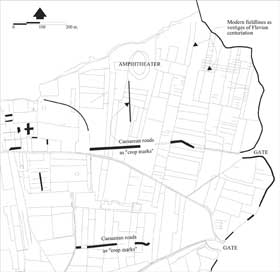
The air photographs have been useful for a number of reasons.
Shadows and vegetation or soil markings highlighting unexcavated
underground features in the landscape, such as roads, ditches
or structures are visible. These features can be helpful when
put together with other forms of information, such as the surveyed
and excavated roadways.
Before performing any analysis
of any of the photographs it is necessary to first rectify its
geometry in calibration with the existing maps and surveyed
data. Therefore, each photograph is scanned at the resolution
of 400 dpi (dots per inch) using a desktop flatbed scanner (UMAX
PowerLook 2100XL) and rectified using the resampling program
included in CAD Overlay, (discussed below under GIS applications).
The control points needed for this operation are taken from
the topographical maps. The corners of buildings or the intersection
of field boundaries have proven to be most precise. Once the
photograph has been successfully rectified, it is possible to
display it as a backdrop to the AutoCAD drawings using CAD Overlay.
In this way one is able to trace over the crop and soil marks
and study them in conjunction with other surveyed or map data.
High altitude air
photographs at a scale of approximately 1:37,500, taken in 1987
by the Greek Army Mapping Service, have helped us to understand
the overall pattern of the roads and field boundaries in the
larger terrain surrounding Ancient Corinth. Control points necessary
to rectify these photographs are taken from the topographical
maps or satellite images, where we do not have a detailed map
of the entire area covered by the photograph.
A series of low level
balloon photographs at an approximate scale of 1:1750 taken
by Dr. and Mrs. J. Wilson Myers in 1986 have greatly assisted
in the identification of details in the landscape at the Roman
harbor of Lechaeum. These balloon photographs have been successfully
rectified to both the low level air photographs as well as the
1:2000 scale topographical maps.
|
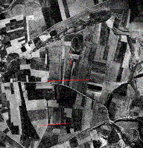
Photograph
by the Hellenic Air Force, 1963. Courtesy of the Corinth Excavations,
American School of Classical Studies at Athens
Click on the
plans to enlarge.
|
;)
;)