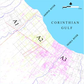
Figure
x:
Flavian
centuriation, ca. A.D. 70. Detail of A2 and A3 units illustrating
evidence from field lines, property lines, roads, ledges, and
paths. Yellow indicates evidence for the A2 grid, and magenta
for the A3 grid.
Click
on the plans to enlarge.
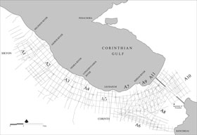
Figure
x: Flavian centuriation, ca. A.D. 70, showing restored
grid of 16 x 24 actus units.
|
Lorem ipsum
dolor sit amet, consectetur adipisicing elit, sed do eiusmod tempor
incididunt ut labore et dolore magna aliqua. Ut enim ad minim
veniam, quis nostrud exercitation ullamco laboris nisi ut aliquip
ex ea commodo consequat. Duis aute irure dolor in reprehenderit
in voluptate velit esse cillum dolore eu fugiat nulla pariatur.
Excepteur sint occaecat cupidatat non proident, sunt in culpa
qui officia deserunt mollit anim id est laborum.
Sed ut perspiciatis
unde omnis iste natus error sit voluptatem accusantium doloremque
laudantium, totam rem aperiam, eaque ipsa quae ab illo inventore
veritatis et quasi architecto beatae vitae dicta sunt explicabo.
Nemo enim ipsam voluptatem quia voluptas sit aspernatur aut odit
aut fugit, sed quia consequuntur magni dolores eos qui ratione
voluptatem sequi nesciunt. Neque porro quisquam est, qui dolorem
ipsum quia dolor sit amet, consectetur, adipisci velit, sed quia
non numquam eius modi tempora incidunt ut labore et dolore magnam
aliquam quaerat voluptatem. Ut enim ad minima veniam, quis nostrum
exercitationem ullam corporis suscipit laboriosam, nisi ut aliquid
ex ea commodi consequatur? Quis autem vel eum iure reprehenderit
qui in ea voluptate velit esse quam nihil molestiae consequatur,
vel illum qui dolorem eum fugiat quo voluptas nulla pariatur?
|
;)
;)
;)
;)
;)