|
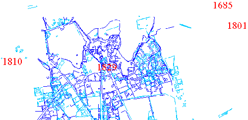
Figure 1
Corinth in the 19th century, northern section;
Digitized by the Corinth Computer Project.
Dark blue represents Corinth in 1831;
Light blue represents Corinth in 1963.
Discussion
of Images: Figures 2, 3,
4, 5, and 6.
Travellers' Texts
Discussion
of Images:
In
this section, I have chosen four images of Corinth from a distance to
give the viewer a sense of the general appearance of the village. The
images range in date from 1685 to 1838 in order also to give a sense
of changes to the village over that period. They also show Corinth from
four different locations: Coronelli is the furthest
away, from the gulf at the north, Dodwell is from
the northeast of the village, Stackelberg
from the northwest and Blouet is from the north,
inside the limits of the village.
The
map (figure 1) above shows the location of the images that will be shown
and analyzed below. Each image is located on the map with a date in
red. This map shows the plan of the village center in 1831 (dark blue)
and in 1963 (light blue). Click
on the dates in the map in order to instantly scroll down to the discussion
of that image below.
Figure 2
Coronelli, 1685: Courtesy
of the Gennadius Library,
American School of Classical Studies at Athens
This
picture, oriented towards Acrocorinth in the south with the Gulf of
Corinth in the foreground, is topographically inaccurate. The several
elevations of the plain are exaggerated, as is the height of the Mount
Oneion on the left hand side of the picture. The ship in the foreground
is western, probably a Venetian ship. The regular rows of buildings
below the Xs on the hillside most likely represent a Venetian encampment,
intended to defend the narrows of the Isthmus (and hence the Peloponnese
from a land attack), and so the Xs might be a fence or wall. Other plans
and maps left by the Venetians suggest that they thought of the entire
Isthmus area, from the fortifications on Acrocorinth to the wall across
the narrows, as a defensive region, and had several lines of defense.
The village of Corinth appears to be as the other descriptions of the
time have it--sparsely settled with fields in between housing clusters.
What they don't describe is the wall that seems to encircle it. Perhaps
this was something the Venetians built themselves, or perhaps it didn't
exist, or perhaps the travellers didn't find it noteworthy. On the second
hillside in the foreground is a structure; this may be the Venetian
fortification found in some plans and from evidence of airphotos.
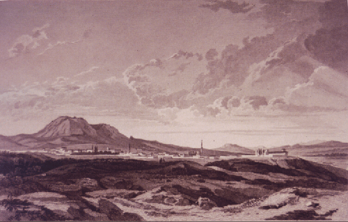
Figure 3
Dodwell, 1801; Courtesy of the
Gennadius Library,
American School of Classical Studies at Athens
This
picture was drawn from a vantage point to the northeast of the village,
somewhere closer to the isthmus. In the 150 years that passed since
the Venetian view, the town appears to have grown. It is walled and
compact. The topography shows a much greater degree of verisimilitude;
the elevations of the levels of the plain and the mountains in the back
look quite similar to what they are today. The structure to the
far right, set off from the rest by some walls but seemingly no other
buildings is most likely the palace of Kamil Bey, the last Turkish Pasha
to rule Corinth. To the left of that is a minaret; this is the "lower"
mosque, whose location is shown on the 1831-33
map. The location of this mosque and images of it in ruins are known,
but space does not permit a detailed exploration of this part of town
at this time. There is a second minaret to the left of the lower mosque;
this is from the "central" mosque, images and descriptions of which
are included in the Bazaar & Mosque section of this exhibition.
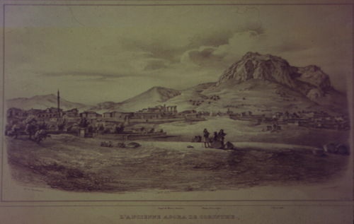
Figure 4
Von Stackelberg, 1810; Courtesy of the Corinth Excavations,
American School of Classical Studies at Athens
This
image is taken from a vantage point to the northwest of the village.
Only one decade had passed in between Dodwell's visit and Von Stackelberg's,
and the appearance of the town is quite similar in the two views. This
similarity is helpful in establishing the versimilitude of the two artists,
and the views of the village are complementary, as they represent the
town from the northeast and the northwest. Again in this image, the
elevations are reasonably accurate, as well as some of the details,
including the large column drum sections in the foreground. These
sections are described also by some of the travellers. Many details
are similar, the location on the plain of the village, the two mosque
minarets, the apppearance of the slopes of Acrocorinth, suggesting that
these details can be trusted. This picture gives some sense of the placement
of the village on the plain--the columns of the temple are in view in
the center of the picture. Judging from the distance from the second
mosque, it would appear that the mosque was located close to the modern
plateia, which fact is confirmed by the 1831-33
map and some of the descriptions in the texts.
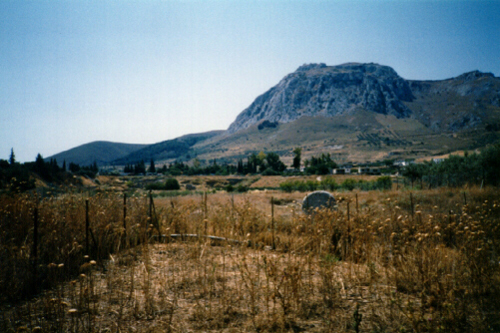
Figure 5
Photograph
by Leslie Kaplan, 1995
For
comparison, I took a modern photograph from the same spot. It
is strikingly similar, which suggests that perhaps Von Stackelberg's
drawings can be considered accurate. The two images can also be
compared side-by-side.
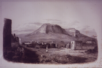
Figure 6
Blouet,
1829; Courtesy of the Gennadius Library,
American School of Classical Studies at Athens
This
image was taken from the north end of the village, but within it. The
small building on the right side of the picture may well be extant still,
used currently as a chicken coop. The state of the village is confirmed
by nearly all of the travellers' descriptions, note in particular the
description by Burnouf from 1856 which describes
the ruins as being primarily on the lower plateau. This picture reflects
that--there is little by the temple, and much in the foreground, though
in this case, it may well be due to the artist's wish to emphasize the
temple
Travellers'
Texts
Randolph
1671-1679:
"Corinth, by the Turks Gouverned, is an Ancient City which stands on
a Rising Ground, about Two Miles from the Sea of the Gulph of Lepanto.
The Houses are much scattered, having many Fields amongst them, together
with which they take up above Three Miles in compass. There are many
pleasant Gardens with all sorts of Fruits. The Houses here are more
for Trade and Pleasure than Security, most having other Houses up on
the Castle which stands upon a Hill...It is above Two Miles from the
Town to the Castle." (1-2)
Spon
1676:
"La ville est au Nord et au Nord-est de cette montagne. Il n'y a que
deux Mosquees et une Eglise de Grecs appellee Panagia, ou demeure le
Metroplitain de Corinthe." (302)
"Il
n'y a quere plus de quinze cens ames dans Corinthe;` mais la campagne
est pleine de villages et de Zeugaris ou Metairies. Entre Sycion et
Corinthe nous en comptames jusqu'avingt-cinq. Ainsi je ne me etonne
pas que le Cady ait, comme on dit, sous la jursidiction trois cent Villages."(305)
Wheler
1676:
"The plain of Corinth, toward Sicyon, or Basilico, is well-watered by
two rivulets, well-tilled, well-planted with olive-yards and vine-yards,
and having many little villages scattered up and down in it, is none
the least of the ornaments of this prospect [from Acrocorinth]. The
town also, that lieth north of the castle, in little knots of houses,
surrounded with orchards, and gardens of oranges, lemons, citrons and
cypress trees, and mixed with cornfields in between, is a sight no less
delightful." (443)
"It
[Corinth] is situated towards the right hand, just within the Isthmus,
on the Peloponnesian Shore, being distant from the Gulph of Corinth,
about a couple of Miles, and from the Saronick Gulph, at least six or
seven...." (439)
"It
is not big enough now, to deserve the Title of a City; but may very
well pass for a good considerable Country Town. It consists of the Castle,
an the Town below it, North of it, and at almost a Miles distance nearer
the Sea. The lower Town lieth pleasantly upon an easie Descent of the
Ground towards the Gulph of Lepanto. The Buildings are not close together;
but in parcels, of half a dozen or half a score, sometimes twenty together;
but seldom more; with Gardens of Orange-trees, Lemons, and Cypress-trees
about them, set with more Regularity, than is usual in these Countries;
and such a distance is between the several Parcels or Buildings, as
that they have Corn-fields between them. The Houses are more spruce
here, than ordinary; and the biggest quarter is, where the Bazar, or
Market place is, consisting of about fourscore, or an hundred Houses.
There are two Mosques here, and one small church, called Panagia; at
which the Arch-Bishop liveth, who was then absent: and few Marks either
of his, or St. Paul's Preaching, Pains or Care of; this famous Church
of Corinth are now to be observed there." (439-440)
Pococke
1736:
"The antient city seems to have been on the spot of the present town,
and to the west of it in the plain: without the town to the north there
are great ruins of a large building of very thick walls of brick, which
might be antient baths or the foundation of some very great building;
for I observed that the rooms which are arched are very small:" (174)
"...The
present town is very small, and more like a village: they have an export
of corn and some oil." (174)
Clarke
1800-1803:
coming from Sicyon "within a mile of Corinth we passed a fountain in
a cavern upon our right, formed by a dropping rock consisting of a soft
sand-stone. Farther up the hill and upon the same side of the road,
as we entered the straggling town now occupying the site of the antient
city, we observed some ruins and a quantity of broken pottery scattered
upon the soil. The old city occupied an elevated level above the rich
plain we had now passed. Upon the edge of this natural terrace, where
it begins to fall towards the corn land, we found the flanked shaft
of a Doric pillar of limestone, equal in its dimensions to any of the
columns of the Temple of Jupiter Olympius at Athens. It was six feet
and one inch in diameter. Close to this we observed the ground-plot
of a building, once strongly fortified; that is to say a square platform
fronting the plain and the sea: on this side of it is a precipice and
its three other sides were surrounded by a fosse. The area measures
66 paces by 53; its major diameter being parallel to the seashore. Upon
the opposite side within the fosse are also remains of other foundations;
possibly of a bridge or causeway, leading into the area on that side."
tries to find a reference in Pausanius to the fountain to figure out
the temple, but can't so surmises it was destroyed when Pausanius came
and so "if this be the case, it may be a relic of the Sisypheum; a mole
or bulwark." (547-548)
Dodwell
1801-1806:
"The present town of Corinth, though very thinly peopled, is of considerable
extent. The houses are placed wide apart, and much space is occupied
by gardens. There are some fine fountains in the town, one of which
is extremely curious, on account of the fantastic ornaments with which
it has been enriched by the singular combinations of Turkish taste."
(192)
"The
chief produce of the territory is corn, cotton, tobacco and oil and
a better wine than that of Athens..." (193)
Turner
1813:
His host tells him that there are 1300 houses in Corinth and 300 are
Turkish, this includes those on Acrocorinth. (295)
"The
houses are very much scattered, and corn grows in the spaces between
them." (295)
Bramsen
1813-1814:
"It is a long straggling place, but can boast of some tolerable good
buildings. It is well-paved and its castle kept in better repair and
in a more compleat state of defense than any I had for some time witnessed,
but they want the convenience of a good harbour." (55)
Williams
1816:
All that remains are "a few Doric columns of an ancient temple, and
some paltry foundations of a theater and a stadium." (392)
500-600
houses, "and these scattered, irregular and with little feature." (393)
Cochrane
1826:
"There is nothing worth notice in Corinth but the fortress; the town
itself from the succession of civil war which it has experienced is
in a most dilapidated state." (311)
Keppel
1829-1830:
"The town of Corinth is one heap of ruins; a few newly-built huts are
the only habitations now standing. Bones of men and horses lie scattered
amongst the rubbish of fallen houses, and attest the last bloody massacre
which visited this once prosperous town." (10)
"There
was considerable cultivation near Corinth. To the westward we observed
some vineyards and olive groves." (12)
Trant
1829-1830:
Not more than 100 cottages standing in ancient Corinth, one of the first
towns destroyed and the last rebuilt. (312)
Fitzmaurice
1832:
"Having got clear of the town which, though poor and insignificant,
still straggles out a long way." (70)
Burgess
1834:
Lands at Lechaion: "After a walk of thirty-five minutes, came to a low
broken cliff which forms a natural wall and has probably been used as
such ever since the days of Cypselus and Periander. We easily surmounted
this cliff and then traversed the stony lanes which wind among the ruined
habitations: these conduct to the upper site of Corinth; and here some
new houses have been built and a street is almost formed." (163)
Population
600 "occupations lie chiefly in the fields." (167)
Quin
1834:
"The town is nearly as shapeless a mass of ruins as Athens itself. But
even here the 'restoration' of Greece was beginning to exhibit itself
in the construction of several new houses which are built in a plain
substantial style." (213)
Temple
1834:
Coming from Kencrae, via Hexamilia. "Having crossed the stream of Eupheeli,
we soon reached a small collection of houses scattered through a large
extent of others in ruins; and this, to my surprise, I found to be Corinth."
(58)
"The
town was entirely destroyed during the last revolutionary war, but a
few houses are rising out of the ashes; the bazaar is tolerably supplied...."
(60)
"In
the rear [of Acro] are two roads, which winding through beautiful valleys
and mountain passes, lead to Argos, Nauplia and etc." (63)
Addison
1835:
"The whole of the houses, with the exception of those just built, in
the centre of the village, being heaps of ruins, destroyed by the Turks,
or deserted by the inhabitants who have been thinned by the sword and
the plague. Bare mud walls, roofless tenements and the shattered remnants
of Turkish mosques present themselves on either side...We traversed
a rugged path over stinging-nettles and stones, past a fragment of a
marble column to the principle street, consisting of a few houses of
wood and shops." (16)
Giffard
1836:
"Climbing over masses of masonry and by ruined walls, we at length arrived
in the main streets of Corinth. Here there was some little appearance
of life and trade, of which the suburbs gave no promise; houses were
building and shops were opened, in some of which we recognized the handiworks
of Birmingham." (100)
Perdicaris
1838-1839:
"The province of Corinth, though the largest in point of territorial
extent, holds the sixth rank in point of population among the provinces
of the Peloponnese. The present number is a little more than 25,000;
while Mantinea, with half the extent, and most of this mountainous,
has more than 53,000 people. Even in its present state of depopulation
Corinth yields to the national treasury an annual income of more than
600,000 drachmas and might be made to yield three and even four times
this amount under a different management..." (25)
Cusani
1840:
In 1840, there were 1500 inhabitants, "d'ogni parte sorgevano nuove
fabbriche, e l'agricoltura rifioriva colla coltivazione dei grani, degli
ulivi e della vite." (184)
Hettner
1852:
"The Corinth of to-day is a small town just struggling again into importance,
with a few thousand inhabitants." (134)
Olin
1852:
"A few of the houses are substantially built of stone, most are mud
cottages. The population is 1200. It must have been much larger before
the revolution, judging from the ruined houses, which as everywhere
else in Greece, attest to the barbarous spirit in which the fierce contest
was waged." (142)
Howe
1853:
"Since the Greek revolution, quite a town has sprung up here, but the
location is very unhealthy. This circumstance if no other, precluded
it from becoming the capital of the new kingdom under Otto. There are
many ruined and desolate walls of dwellings destroyed in the devastation
of the revolution still standing." (35)
Baird
1855:
"On our return to Corinth, we spent a short time in the examination
of the only objects of interest that remain in the site of a city which
once exceeded Athens for commerce and population--a temple in the very
midst of the modern village, and an amphitheater about three quarters
of a mile east of it. ...All the loose stones have been incorporated
into the buildings of the village, to which they were so conveniently
situated." (158)
"The
village of Corinth barely contains a couple of thousand inhabitants.
It's houses are low and poorly built." (158)
Burnouf
1856:
"L ville moderne est sur le sol de l'ancienne ville. Elle s'etend horizontalement
et forme une zone etroite au pied de l'acrocorinthe. Trois gradins paralleles
au rivage: Le premier est au pied de la montagne et supporte la ville
moderne; le deuxieme est au-dessous, a la hauteur d'une tour qui porte
le nom de Kiamyl Bey; le troisieme est a mi-chemin entre celui-ci et
la mer; la plaine qui forme le dernier niveau est cette alluvion recente
qui s'agrandit chaque jour et suit la rivage bien au de la Sicyone et
jusque vers l'embouchure du Crathis. Entre la ville et la tour de Kaimyl-Bey
s'entend un vaste champ de ruines; ce sont les maisons de la ville turque,
detruites lors de la guerre de l'independence et dont les murailles
a demi renversees recouvrent d'autres ruines que firent a d'autres epoques
d'autres barbares." (on that plain was destroyed the army of Drama Ali--28,000
men's bodies lay there for a long time) (41)
Taylor
1857:
"A ride of half an hour brought us to Corinth--or rather what had been
Corinth--for although a few houses were standing, they were cracked
from top to bottom and had been abandoned. The greater part of the city
was a shapeless heap of ruins and most of the inhabitants seemed to
have deserted it." (156)
"The
government decided to remove the town of Corinth to a new site on the
plain, two or three miles nearer the gulf. No commencement has been
made, however, and I doubt whether the people will second this measure."
(157)
Clark
1858:
The village of Corinth is immediately below to the North "standing about
those dark columns. The grounds about it, how green with wheat and maize
and vines descends in a succession of terraces to the belt of the barren
sand which lines the shore." (58)
"Of
all the buildings, sacred and secular, of the old city, no trace remains,
except a few unsightly heaps of Roman brickwork, which have outlived
their history as completely as the pyramids. The ancient walls, famed
for their dimensions have entirely disappeared." (55)
Pressense
1864:
"La nouvelle Corinthe n'est qu'un chef-lieu improvise. Que ne deviendrait
pas une ville ainsisituee s'il y avait des routes pour le rejoindre,
une protection efficace pour y maintenir la securite et un peu de cette
confiance dans l'avenir sans laquelle l'esprit d'enterprise ne saurait
se developper."
Jerningham
1870:
"The site of old Corinth, which may before the great earthquake of 1858
have been a picturesque town, with its mosques and houses intermingling
with cypresses and with gardens of orange and other fruit trees, but
which now presents the dreariest of modern aspects." (85-86)
Belle
1875-1878:
All have moved to New Corinth. (257)
Smith
1883:
"We drove into the streets, or rather the ruins, of old Corinth. Few
villages are more desolate." (102)
"The
chaos of broken walls which stand upon its site is all that remains
of a town which was destroyed by the Turks and finally abandoned on
account of repeated earthquakes." (103)
"Amongst
the ruins, only two houses seemed not quite dismantled." One was a priest's
house where they stayed. (104)
|
;)
;)