[Introduction]
[Methodology] [Greek and
Roman Corinth] [Modern Corinth] [Contributors]
[Reference] [News]
Introduction | Methodology | Timeline | Village Maps | Views | Temple of Apollo | Bazaar & Mosque | Bibliography
|
Discussion
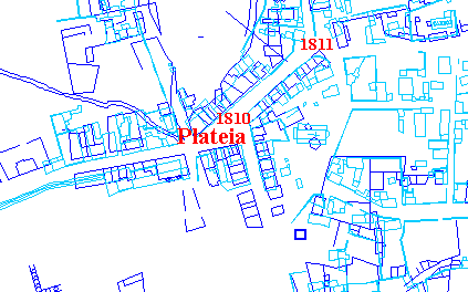
of Images: Figures 2, 3,
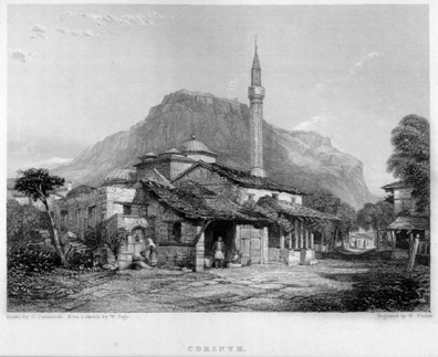
4, and 5. The map (figure 1) above shows the location of the images that will be shown and analyzed below. Each image is located on the map with a date in red. This map shows the plan of the village center in 1831 (dark blue) and in 1963 (light blue). Click on the dates in the map in order to instantly scroll down to the discussion of that image below. There are three views of the central mosque and the bazaar in my collection, but I do not yet have permission to show the third, which is a view from the south. The two pictures, (figure 2, figure 4) however, showing the central mosque, the bazaar and several of the roads, confirm the identification of the old bazaar with the modern plateia, the identity of the Turkish roads in the area with the modern roads, and the shared site of the mosque and the modern church. This is supported by the comparison between the 1963 map and the 1831-33 map as shown in figure 1 above. The images provide other evidence for the appearance of the village in the 19th century beyond just its layout. The three of them together provide a view of the central mosque and the area around it from three different sides, providing a kind of 360 degree view of that central neighborhood.
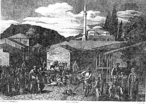
Although figure 2 is not labeled, it seems to be a likely candidate for the village bazaar that is described by the travellers. Behind the bazaar is a large mosque with a short minaret and (to its right) a small outbuilding, probably hexagonal or octagonal. To the left of the building with the horses in front is what appears to be a street--one can just make out the people walking down it away from the bazaar. The distinctive outline of Mount Gerania, with the projection at the far right, makes it clear that the view is taken looking east. Using the location of the bazaar and central mosque from the 1831-33 map as a guide, it seems likely that that is indeed what this image is.
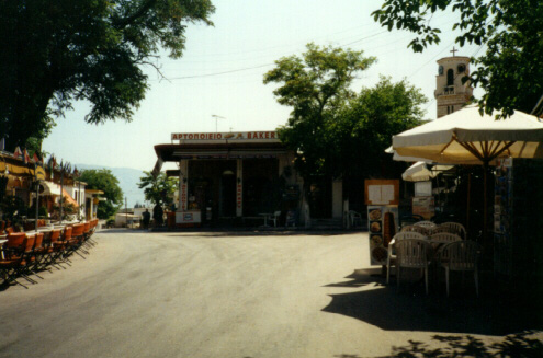
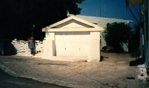
One can compare this image with a modern photo, figure 3, taken of the east side of the modern plateia with the church in the background. A side-by-side comparison shows that it is strikingly similar. In figure 1 where the 1831-33 map is superimposed on top of the 1963 map, it is easy to see that the modern church (in light blue with a cross at center, to the left of the word "plateia") is built on the site of the old mosque (the two small dark blue hexagonal builidings on top of the church and the dark blue rectangular building with the semicircle attached just above and to the left of the church) and that the modern bazaar is on the site of the old. The roads in this area also seem to be on their pre-independence locations; the one to the right of the Von Stackelberg image is the same as the one in the modern photograph. This evidence confirms the similarities of the two town plans and the location of some of the central features of the old village.
After making the discovery of the location of the central mosque, this picture, figure 4, became interesting. Several clues led me to conclude that it is also an image of the central mosque, this time from the east, looking northwest. This is the back side of the Stackleberg image. The location of the minaret in relation to the mosque, and the orientation of the two smaller domes suggest that the mosque faced west, as the central mosque did. The outbuilding to the northeast is also suggestive of the plan of the central mosque. The road going off to the right and back of the picture is then the road featured in the right hand side of the Von Stackelberg image.
And finally, the fountain in the central foreground clinched the identification; as seen in the modern photograph, figure 5, there is a fountain which is now located on the other side of the same street. A side-by-side comparison shows this similarity. Descriptions which use the remains of the temple, the bazaar or the central mosque can now be examined with an eye towards placing them. Travellers' Texts Spon
1676: Wheler
1676: "There is also another Ruin on the North-side of the Bazar, of Brick-work; which looks like part of some Temple or a Roman Bath." (440) Clarke
1801-1803: "...This temple occupied the same situation with respect to the agora that the present ruin does with regard to the Bazar; and it is well-known that however the prosperity of cities may rise or fall, the position of the public mart for buying and selling usually remains the same." (555) Temple
1834: Addison
1835: Giffard
1836: |
;)
;)
;)
;)
© David Gilman Romano and the Corinth Computer Project.
Site design and maintenance by Dan Diffendale