[Introduction] [Methodology]
[Greek and Roman Corinth] [Modern
Corinth] [Contributors] [Reference]
[News]
Introduction | Director's Welcome | Project History | Awards and Reviews
|
by Susan Lonkevich,
Visitors to the Web site can find three-dimensional models of the remains of what may be one of the oldest amphitheaters of the Roman world, where gladiators and bears once performed. After flying over the city to get a sense of its terrain, they can step into the forum as it exists today by using a 360-degree photographic panorama. Stapp is also working on a digital video tour of the site, along with a gallery of interior 3-D photographic panoramas, and promises that the result will be a major armchair-tourist experience. Depending on their interests, Stapp says, visitors to the site can turn on and off layers of information. If you are a scholar interested in studying city planning, for example, you could go to our site, filter everything out but the drainage material and see what the waterworks was [like] for this ancient city. Over the summer, Romano and his students embarked on a new computer-mapping project in the Mugello Valley of Tuscany, in conjunction with an Italian university. His long-term goal is to create a research center that can continue this kind of work at different archaeological sites around the world in affiliation with the University Museum and several schools at Penn. He also has been promoting the idea of creating a masters program in mapping and field archaeology to acquaint students with technology like Geographic Information Systems software and remote sensing. The significance of such tools is evidenced by Romanos discovery of a second Roman colony at Corinth, founded between 70 and 80 A.D. during the reign of Vespasian. That all comes from remote sensing and the creation of precise digitized maps, he notes. We wouldnt have been able to do this without computers. And while he doesnt foresee such methods replacing old-fashioned pick-and-shovel work, Romano firmly believes that the new digital tools he and his colleagues have created will be extremely valuable to future archaeologists. Susan Lonkevich's e-mail address is lonkevich@ben.dev.upenn.edu. Follow this link to read the article at its own site.
PENN Arts & Sciences is a news letter that is produced by the school of Arts & Sciences at the University of Pennsylvania, it is distributed to Alumni, faculty and staff of the school. This issue is dedicated to the ongoing research of Classical studies within the school. Dr. David Gilman Romano and Corinth Computer Project are featured in this issue of the news letter. Follow this link to read the article at its own site.
A high-tech window into ancient Greece You can "fly" over a 3-D version of the landscape at Corinth, and zoom in and out of interactive plans of the excavations. Researchers at Penn developed the Web site. By Martha Woodall INQUIRER STAFF WRITER Researchers from the University of Pennsylvania Museum of Archaeology and Anthropology have been applying some new tools to their study of the ancient Roman colony at Corinth. For 12 years, the Corinth Computer Project has been using laser-assisted electronic surveying equipment, satellite imagery, geographical-information-system software, and 3-D rendering techniques to develop detailed maps, plans and images of the city that Julius Caesar founded in Corinth, Greece, in 44 B.C. The project director, David Gilman Romano, realized that applying the latest technology to archaeological research could help scholars learn more about this important site that the American School of Classical Studies at Athens has been excavating since 1896. Technology also has enabled Romano, who has been working under the auspices of the American School, to share his findings with the public through his project's Web site: http://corinth.sas.upenn.edu/corinth. html By downloading free plug-in software through links at the site, visitors can "fly" over a 3-D rendering of the landscape, and zoom in and out of interactive plans. By turning "layers" of the plans on and off, they can use a color-coded table to identify when parts of a structure such as the city's Roman forum were built and what material they were made of. They can view a 360-degree panorama of the ruins at Corinth today. Visitors also can learn how ancient historians described what they observed in Corinth by clicking links to the Perseus Project, a digital library of classical texts maintained by Tufts University in Somerville, Mass.: http://www.perseus.tufts.edu "Obviously, this is scholarly and accurate," a research associate, Nicholas L. Stapp, said in the Corinth Computer Project's tiny quarters in the museum. "But we have tried to gear it a lot more toward K-12, college students . . . and the general armchair tourists." Romano and Stapp know there is widespread interest in the Romans. The project receives e-mail from fifth graders as well as classics scholars. And they suspect that the success of the movie Gladiator will stimulate more curiosity in Rome. Stapp is adding information to the Web site about a large amphitheater the Romans built on the outskirts of Corinth. He is creating a virtual 3-D model, and adding photographs and a 360-degree panorama of the amphitheater area, which has never been excavated. "Corinth is one of the only cities in the Roman East that had an amphitheater," Stapp said. "They had gladiators. They had animals. The things you see in the movie, they had here." The history of Corinth has long fascinated archaeologists and scholars because it played a pivotal role in both ancient Greece and Rome. The city occupies a strategically important spot on the Isthmus of Corinth, the land bridge that connects the mainland of Greece with the Peloponnesos, or peninsula. "It was a very important Greek city," Romano said. "It was the equal [of] - or, actually, more important than - Athens in the Greek period. . . . It was destroyed by the Romans in 146 B.C. because Corinth led the opposition to the coming of Rome. It was destroyed in the same year that Carthage was destroyed. It lay dormant for 102 years until 44 B.C. when the Romans came back to found a new colony." Corinth became the capital of Roman Greece. The Apostle Paul lived there for a time. Corinth later became an important Byzantine site. Romano, an archaeologist, studied at the American School of Classical Studies in Greece in the 1970s. He worked on the excavations at Corinth, and wrote part of his doctoral dissertation on its race courses. In 1988, Charles K. Williams 2d, then the director, asked his former student to return to study one problem: how one of the Roman temples was oriented in relationship to one of the roads, and how that related to the Roman forum. "This is the way he sort of got my foot in the door," Romano recalled. But Romano took what was a small question about Roman city planning that involved 1.1 square kilometers, and began to create a map of the ancient city and, later, the surrounding countryside. The project now encompasses nearly 700 square kilometers, or about 266 square miles. For 10 summers, Romano conducted field work with students in Corinth to map the roads and above-ground structures in the city. To make the maps, he used state-of-the-art surveying equipment called an electronic total station that combines computers and lasers. During the academic year, he and Penn students built a database to house the information that had been collected over the years from the Corinth excavations, digitized the information, and analyzed it. Through this process, Romano discovered the grid system the Romans used to lay out the city, and uncovered evidence of a second Roman colony that the Emperor Vespasian had founded in the A.D. 70s. A graduate of the Institute of Archaeology, University College London, Stapp joined the project five years ago. In addition to training Penn students for work on the project, he has been instrumental in developing the Web site. "We actually had an initial page up in 1997," Stapp said. "But one of the recent pushes, post-'97, has been to make as much of our published data available on the Internet as possible . . . so people could see what we are doing." The wealth of detail about Corinth is available because excavation has been going on for a century. "Whenever archaeologists worth their salt excavate a structure, they take photographs of what they have excavated, and then they identify everything they can," Stapp said. "One of the things they usually identify is the chronology of different constructional elements, the materials used, and the function." He and Romano decided to incorporate that information into their digitized plans of Roman structures using a special browser plug-in that can be downloaded from the site. He said the plug-in allowed visitors to view and manipulate drawings that have been created with AutoCAD - computer-aided-design software used by architects and engineers - without having to install that software on their own desktops. "Anybody who has this plug-in can go see the forum," Stapp said. "You can zoom in to each individual structure. And you can click on anything, and it will tell you the date, the material and the function. " That detail is available for buildings in the center of the excavated city now, and will be for the entire study area later. "Stone-for-stone drawing like this does not exist for any other ancient city," said Romano, who has published papers on the Corinth Computer Project and described it at international archaeology meetings. "This is not only a city, but it is a very important ancient city, so this will be the model for other archaeological sites." Martha Woodall's e-mail address is martha.woodall@phillynews.com
SNAPSHOT/Wherein the intrepid Web explorer does his best Indiana Jones imitation. The hunt for Orange Julius Caesar By Russell Campbell III As a child, I wanted to be Indiana Jones. I envied his search for the unknown, battling unforeseeable odds to gain a bit of knowledge for mankind. Yet childhood and two sequels inevitably passed and I moved on to new heroes. Like the apostle Paul, I put away my childish things. Not so fast Why, just last week I was standing in front of the forum in ancient Corinth. Well, I was virtually standing there, thanks to the Corinth Computer Project. Since 1988, Senior Research Scientist David G. Romano, Ph.D., and the Mediterranean Section of the University of Pennsylvania Museum, under the auspices of Charles K. Williams, Ph.D., and the American School of Classical Studies at Athens, have been using computer software to map out the Roman colony of Corinth. Two months ago the most modern version of the ancient city went cyber and so did my chance at becoming the great archaeologist. Technology has made a huge leap, said site designer and research associate Nick Stapp, M.Sc., who, in his clean-cut clothes, looks as much like Indiana Jones as I do. Even with low-budget commercial software we were able to develop a plan of the city in specific chronological periods. So I took a tour. From the Web page, corinth.sas.upenn.edu , a big stone block a surveyors tomb from Northern Italy directed me around the site. A quick click to the city plan gave me a layout of the city in A.D. 150. I dusted off my fedora and followed a link to a photographic 360-degree panorama of the excavation area of the forum, with me standing right in the middle of the excavation. What to do next? Perhaps Ill be hungry or in need of some new khakis (the non-sweatshop variety, of course), so Ill follow the links to the basilica, a mall-type map without the familiar names like The Wall or Urban Outfitters. Hey. Theres Orange Julius Caesar. Then Im off to a 3-D fly-through via the landscape link. Nick said hes going to put up some more 3-D fly-throughs eventually. I cant wait. In all seriousness, the site is an extraordinary resource for those interested in ancient civilization. Romano and Stapp plan on updating the site frequently with more information and features from the wealth of knowledge they have on Corinth. Excavations in the city have been taking place since 1896, and only a small fraction of the actual city has been unearthed, so there is no want for material.  April
7, 2000 April
7, 2000
Science Magazine
Volume 288, Number
5463, Issue of 7 April 2000 ©2000 by
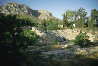
The American Association for the Advancement of Science. Written by: Jocelyn Kaiser NetWatch COOL IMAGES: Virtual Excavation Entertainment complexes may be all the rage today, but they were also in vogue around A.D. 150 when Herodes Atticus expanded an odeum (a small concert theater) in the Roman colony of Corinth in Greece. Find out who else likely added to this and other buildings in this port city--a model of Roman planning--by clicking on drawings at the Corinth Computer Project at the University of Pennsylvania. The stone-by-stone interactive drawings are at the forefront of Web archaeology, says project director David Romano. He and research associate Nicholas Stapp have packed the site with photos, animations, and satellite images that explain how over the past 12 years their team has gleaned telling details from Corinth's ruins.
David Gilman Romano and Nicholas L. Stapp, Mediterranean Section, University of Pennsylvania Museum of Archaeology and Anthropology Nationwide Applications
Contest: The Best of the Best, Winners 2000
Since 1988, the Corinth Computer Project of the University of Pennsylvania Museum of Archaeology and Anthropology -- under the auspices of the American School of Classical Studies, Corinth Excavations -- has been undertaking a computerized architectural and cartographic study of the Roman colony of Corinth, Greece, founded by Julius Caesar in 44 B.C. The project has three goals: to study the nature of the city planning process during the Roman period; to gain a more precise idea of the order of accuracy of the Roman surveyor; and to construct a series of highly accurate computerized maps of the ancient city. The initial study area of the project covered 0.006 square kilometers. The study area presently encompasses approximately 700 square kilometers. The research lab uses cutting-edge technology and traditional methods to meet our goals. Methods include the use of computer-aided design (CAD), total station survey, GIS, remote sensing, three-dimensional modeling, and Web programming. We use these technologies to accurately digitize site data and post it on our Web site (http://corinth.sas.upenn.edu) for simulating and analyzing scenarios as well as educating the general public. The site went live in 1996, presenting the viewer with static GIS data and three-dimensional stills. Today, visitors can interact with our GIS and three-dimensional models dynamically. Using a conventional total station, we have documented the exact locations and orientation of approximately 12,748 physical features. We employ a CAD program to read the surveyed data, which allows us to digitize, fit, and orient plans and maps to the surveyed data at 52 centimeters. We then import the digitized CAD data into a GIS program for analysis and interpretation. Three times a year, we create three-dimensional models using our GIS in conjunction with image analysis software and a modeling program. We start with digitized contour data from topographic maps and assign a z value to the digitized data. We then render either a wire-frame or triangulated irregular network model out of this three-dimensional vector data. Next, we drape a ground level of remote sensing data over this model for relief mapping and enhanced visualization. From these three-dimensional models, we create virtual reality modeling language simulations and movies for posting on the Web site, enabling visitors to virtually fly through three-dimensional historical recreations of Corinth. Currently, the project Web site also allows Internet users to view GIS, remote sensing (low/high level aerial photographs and satellite images) data, and topographic maps at varying scales as well as interact with stone-for-stone archaeological plans of the ancient city of Corinth. The Corinth Computer Project Web site also contains traditional excavation data and published reports. The traditional data supplement the technical methods by providing a wealth of archaeological and historical information about the site. The excavated data come from an ongoing study of the ancient city conducted by the Corinth Excavations of the American School of Classical Studies at Athens, which began in 1896. The Web site has been a valuable tool for teaching various aspects of archaeology in the classroom, offering unique educational opportunities for K12 as well as university students. We hope that the Corinth Computer Project Web site will eventually serve as a central store of information to enable archaeologists in the field to share information quickly. The Corinth Computer Project collects survey data about archaeological finds using a Set-3 total station and an SDR-2 handheld computer from Sokkia (www.sokkia.com). For CAD applications, the lab employs AutoCAD and CAD Overlay from Autodesk (www.autodesk.com) and MicroStation/J from Bentley (www.bentley.com). It employs ArcView and Spatial Analyst from ESRI (www.esri.com) to analyze field data and ESRI's Image Analysis and ERDAS's (www.erdas.com) ERDAS IMAGINE to prepare remote sensing data for 3D models. The actual models are created using Autodesk's 3D Studio Max and exported as virtual reality modeling language movies for posting on the Internet. The lab uses satellite imagery from Space Imaging(www.spaceimaging.com) and Spot (www.spot.com). |
 Sept./Oct.
2000
Sept./Oct.
2000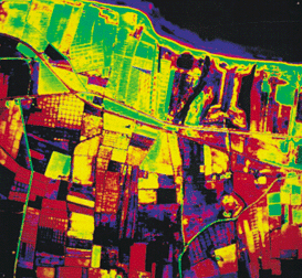
 Summer
2000
Summer
2000 May 18, 2000
 August
2000
August
2000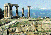 2ND
PLACE--Flying Through the Past
2ND
PLACE--Flying Through the Past© David Gilman Romano and the Corinth Computer Project.
Site design and maintenance by Dan Diffendale