Directed by Dr. David Gilman Romano
    AML Home  |  Projects  |  Methodology  |  News  |  People  |  History  |  Training  | GIS @ Penn  |  Blogs  |  Seminars & Conferences  | Advisory Board  |  Contact


Digital Augustan Rome
Mapping Augustan Rome was an attempt to visualize as well as to document the city of Rome as it existed in A.D. 14. The project sought to bring together the archaeological, historical and literary evidence for the Augustan city, and resulted in a volume as well as maps. The digital version promises to bring together many sources of data on Augustan Rome not included in the book or in the paper maps. The gathering of new information and its conversion to a digital format will give a new kind of resource for the study of the Augustan city. The resulting digital successor will not only serve future scholars and students but will have the capability of being revised and updated.

To learn more, visit http://digitalaugustanrome.org


Detail of 1:6000 map of Augustan Rome


Mt. Lykaion Excavation and Survey Project
In the ancient Greek region of Arcadia in the southern Peloponnesos, the sanctuary of Zeus on Mt. Lykaion stands out for its great fame, mysterious rituals and wide-ranging significance. This site held fascination for the ancient Greeks and has continued to be important for modern-day scholars of archaeology, classics, and Greek religion. In 1996 Dr. David Gilman Romano of the University of Pennsylvania Museum conducted an important architectural and topographical survey at the site. Following a two year preliminary planning phase of cleaning and survey in 2004-2005, a research team from the University of Pennsylvania Museum of Archaeology and Anthropology and the University of Arizona, in collaboration with the Thirty-Ninth Ephorate of Classical and Prehistoric Antiquities, began a four-year excavation program in June 2006.

To learn more, visit http://lykaionexcavation.org


From top to bottom, photostitch, hand-drawings, AutoCAD, and final elevation
of part of the stoa at Mt. Lykaion.
 

Corinth Computer Project
Since 1988 a research team from the Penn Museum has been involved in making a computerized architectural and topographical survey of the Roman colony of Corinth. Known as the Corinth Computer Project, the field work has been carried out under the auspices of the Corinth Excavations of the American School of Classical Studies at Athens. The original objectives were to study the nature of the city planning process during the Roman period at Corinth; to gain a more precise idea of the order of accuracy of the Roman surveyor; and to create a highly accurate computer generated map of the ancient city whereby one could discriminate between and study the successive chronological phases of the city's development. During the course of the twenty years of the project to date, the nature of the research has evolved from a fairly straightforward consideration of the location and orientation of the excavated roadways of the Roman colony, to a more complex topographical and architectural consideration of various elements of the colony, including the rural as well as the urban aspects of planning and settlement. The project now utilizes a number of methodologies simultaneously in the overall study of the ancient city. One aspect of the project is a regional landscape study of a portion of the Corinthia, with the city of Roman Corinth as the focus. Another aspect of the project is the effort to include information from the city of Corinth from chronological periods other than Roman, specifically Archaic and Classical Greek, Hellenistic, Late Roman, Byzantine, Frankish, Venetian, seventeenth through twentieth centuries.

To learn more, visit http://corinthcomputerproject.org


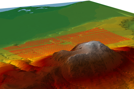
Digital Terrain Model of the Corinthia, with the restored Roman city
"drawing board" plan, looking northeast.


© David Gilman Romano